|
Buy ⁄ View
|
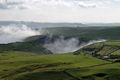
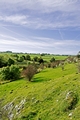
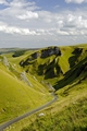
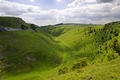
Low Lying Cloud in Winnats Pass
Low lying cloud in Winnats Pass, near to Castleton in the Derbyshire Peak District of England. This scene was captured from Mam Tor. The same cloud had, just a short time earlier, engulfed the road as I was approaching the area by car.
Image Ref. 34029-RDA
|
|
Buy ⁄ View
|
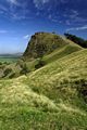
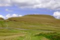
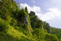
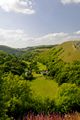
Back Tor, near to Castleton
Back Tor, which is near to Castleton, in the Derbyshire Peak District of England. This view, looking north west, shows the steep, rugged nature of the hill. Bac Tor is situated between the Vale of Edale, and the Hope Valley and is one of the hills which form the Great Ridge.
Image Ref. 34113-RDA
|
|
Buy ⁄ View
|
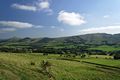
Great Ridge Hills, from the Pennine Way
Hills of The Great Ridge, as viewed from the Pennine Way, near to Edale, in Derbyshire, England. This Peak District view, along the Vale of Edale, shows the following hills from left to right; Lose Hill, Back Tor, Hollins Cross and Mam Tor.
Image Ref. 34337-RDA
|
|
Buy ⁄ View
|
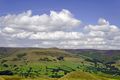
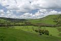
Across the Valley to Grindslow Knoll
A view across the Vale of Edale to Grindslow Knoll, in Derbyshire, England. This scene in the Peak District National Park, was captured from a viewpoint at the bottom of Mam Tor. The village of Edale, can be seen to the far right.
Image Ref. 29649-RDA
|
|
Buy ⁄ View
|
Bunster Hill from Thorpe Cloud
A view of Bunster Hill, as photographed from Thorpe Cloud, at Dovedale in Derbyshire and Staffordshire, England. The limestone hill rises steeply from the valley floor and the River Dove, which marks the county boundary, can be seen winding its way through the valley and also the Staffordshire side footpath, is shown along side it.
Image Ref. 31202-RDA
|
|
Buy ⁄ View
|
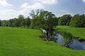
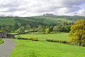
Riverside Meadows, Ashford-in-the-Water
A countryside scene of the River Wye and some of the riverside meadows at Ashford-in-the-Water in Derbyshire, England.
Image Ref. 31394-RDA
|
|
Buy ⁄ View
|
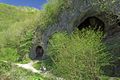
Dove Holes, Dovedale
Dove Holes in Dovedale, Derbyshire, England. Two huge caves known as Dove Holes, in the limestone rock on the Derbyshire side of the valley. These caves were formed during the two ice ages and there has been evidence of human activity in them, dating back to 13,000 BC.
Image Ref. 31112-RDA
|
|
Buy ⁄ View
|
Pickering Tor, Dovedale
Pickering Tor in Dovedale, Derbyshire, England. The limestone rock formation known as Pickering Tor, is pictured here on the Derbyshire side of the valley. The Ilam Rock Bridge is also shown spanning the River Dove at this location, which is approximately halfway between Milldale and the Stepping Stones.
Image Ref. 31125-RDA
|
|
Buy ⁄ View
|
South West from Thorpe Cloud Summit
A view looking south west from the summit of Thorpe Cloud at Thorpe in Derbyshire, England. This aerial view shows the pasture land around Thorpe Mill Farm in the centre of the photo. Then beyond the diagonal tree line from the right is the county boundary and the countryside of Staffordshire near to the village of Blore.
Image Ref. 31188-RDB
|
|
Buy ⁄ View
|
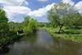
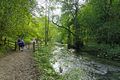
The River Wye from Bakewell Bridge
A view looking upstream along the River Wye, from Bakewell Bridge, at Bakewell in Derbyshire, England. The scene includes a riverside footpath with people walking and sitting on benches and cattle grazing in the field.
Image Ref. 31365-RDA
|
|
Buy ⁄ View
|
Ilam Rock and Ilam Rock Bridge
Ilam Rock and Ilam Rock Bridge at Dovedale in the Peak District, England. The footbridge, which spans the River Dove, is a much used river crossing. This view point is from the Derbyshire side, across to the limestone rock on the Staffordshire side.
Image Ref. 31120-RDA
|
|
Buy ⁄ View
|
Dove Valley, Beside the River
Along Dove Valley beside the River Dove, in the Peak District, England. The river marks the county boundary and this view, looking north towards Milldale, shows the Staffordshire side on the left and Derbyshire on the right, with the footpath. All along this limestone gorge, are areas of woodland, rocks and steep grassy slopes.
Image Ref. 31133-RDA
|
|
Buy ⁄ View
|
Across the Valley, Thorpe to Ilam
A view across the valley, from Thorpe in Derbyshire to Ilam and Bunster Hill In Staffordshire. The scene shows Ilam in the distance surrounded by trees, a hotel complex in the centre and Bunster Hill on the right. The line of trees across the valley, marks the position of the River Dove and county boundary.
Image Ref. 30913-RDA
|
|
Buy ⁄ View
|
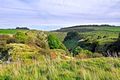
Looking Down into Lathkill Dale
From a high viewpoint next to the disused Ricklow Quarry, this is a scene looking down into Lathkill Dale. The location is near to Monyash in Derbyshire, England.
Image Ref. 21380-RDA
|
|
Buy ⁄ View
|
Bunster Hill Footpath at Ilam
Along the footpath from Ilam; this view is looking due north, across the slopes of Bunster Hill in the Staffordshire Peak District of England. The sunshine was struggling to break through the mist cover.
Image Ref. 30655-RDA
|
|
Buy ⁄ View
|
Approach to Air Cottage near Ilam
The approach to Air Cottage in the hills above Ilam, in Staffordshire, England. This a popular walk from the village of Ilam, either across Bunster Hill, or skirting it, and then on to Ilamtops Farm and Air Cottage. Just through the gate or cattle grid, the footpath turns off to the right and follows a winding route down through Dovedale Wood to Ilam rock, which is beside the River Dove. The distant hill is on the Derbyshire side of the Dove Valley.
Image Ref. 30683-RDA
|
|
Buy ⁄ View
|
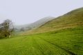
The Ascent of Mam Tor
The ascent of Mam Tor, near Castleton in Derbyshire, England. Around the summit of this 517 m hill, is a late Bronze Age and early Iron Age hill fort. Evidence indicates that the hill, also known as the Shivering Mountain, was occupied from around 1200 BC. Groups of walkers are shown at various stages on their way to the summit.
Image Ref. 29633-RDA
|
|

Buy ⁄ View
|
Rocky Terrain in Lathkill Dale
This scene shows a section of rocky terrain in the upper reaches of Lathkill Dale, near to Monyash in Derbyshire, England.
Image Ref. 21393-RDA
|
|
Buy ⁄ View
|
The Dovedale Dash by Thorpe Mill Farm
Competitors in the Dovedale Dash, pictured crossing pasture land at Dovedale in Derbyshire, England. The runners here, have just passed the Thorpe Mill Farm buildings, on their way towards the river and Thorpe Cloud. The Dash is a cross-country running race which is held annually on the first Sunday of November, and is run between the villages of Ilam and Thorpe, across the fields and along the banks of the River Dove.
Image Ref. 26831-RDA
|
|
Buy ⁄ View
|
Wolfscote Dale from Gipsy Bank
Wolfscote Dale, on the Derbyshire and Staffordshire borders, England. Looking down into the gorge, from a view-point half way up the very steep Gipsy Bank. This scene shows the River Dove and Coldeaton Bridge spanning the river, bounded on both sides by steep hillsides.
Image Ref. 23200-RDA
|
|
Buy ⁄ View
|
Gateway to Lover's Leap, Dovedale
The two walkers photographed here are just going through a gateway on the footpath which leads up a steep incline, through the trees, to the rocky outcrop called Lover's Leap. The footpath is beside the River Dove, in Dovdale, Derbyshire, England.
Image Ref. 30342-RDA
|
|

Buy ⁄ View
|
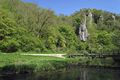
The River Wye at Upperdale
The River Wye, as it gently flows through the hamlet of Upperdale in the Derbyshire Peak District of England.
Image Ref. 29442-RDA
|
|
Buy ⁄ View
|
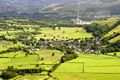
Castleton and the Hope Valley
An aerial view of the village of Castleton, in Derbyshire, England. The viewpoint for this scene was the summit of Mam Tor. Castleton which is set in the western end of the Hope Valley, is surrounded on three sides by hills. In the distance is a cement works.
Image Ref. 29705-RDA
|
|

Buy ⁄ View
|
Walking The Great Ridge
A magnificent view of The Great Ridge, near to Castleton in Derbyshire, England. The scene shows people walking the ridge from the summit of Mam Tor to the distant, Lose Hill. To the left of the ridge is the Vale of Edale and to the right is the Hope Valley.
Image Ref. 29740-RDA
|
|
Buy ⁄ View
|
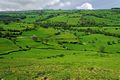
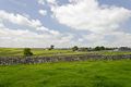
Strip Fields South of Litton
A view across the strip fields, separated by dry stone walls; south of the village of Litton in Derbyshire, England. The open strip field system was in use over much of Europe, after the Middle Ages, where families farmed individual strips of a field. A gradual change to private fields, began in the 12th century.
Image Ref. 29375-RDA
|
|
Buy ⁄ View
|
Cressbrook Dale near to Wardlow
Cressbrook Dale in the Derbyshire Peak District of England. This view looking north, is half way along the dale, and shows the winding footpath with two walkers ahead, and another group of walkers in the centre, on an inclined footpath, which goes to the village of Wardlow.
Image Ref. 29353-RDA
|
|

Buy ⁄ View
|
The Splendour of Dove Valley
The splendour of the Dove Valley, in Derbyshire, England. There are at least two locations along this stretch of Dovedale where a bend in the river and a gap in the woodland, reveals this wonderful lighting effect, on a sunny day.
Image Ref. 30312-RDA
|
|
Buy ⁄ View
|
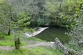
Weir Below Lover's Leap, Dovedale
A weir on the River Dove at Dovedale in Derbyshire, England. This is the scene to be found, after walking down the steps from Lover's Leap, on route to the Stepping Stones.
Image Ref. 30353-RDA
|
|
Buy ⁄ View
|
Lathkill Dale and Fern Dale to Monyash
A view across the dales in the Derbyshire Peak District of England. Beyond and below the fenced off area, is Lathkill Dale, in the central area is Fern Dale and Monyash is to the distant right.
Image Ref. 21384-RDA
|
|
Buy ⁄ View
|
Tissington Spires
Tissington Spires in Dovedale, Derbyshire, England. The spires are limestone columns, which rise up from the valley on the Derbyshire side of the gorge.
Image Ref. 30336-RDA
|
|
Buy ⁄ View
|
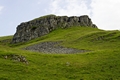
Peter's Stone, Derbyshire
The large limestone outcrop known as Peter's Stone, located above Cressbrook Dale and near to the village of Litton in the Derbyshire Peak District of England.
Image Ref. 28915-RDA
|
|
Buy ⁄ View
|
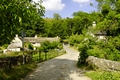
Ilam Primary School and Cottages
The Church of England (VA) Primary School and cottages in the village of Ilam, Staffordshire, England. The school with its Alpine style architecture, is just one of many attractive features of the village.
Image Ref. 26920-RDA
|
|
Buy ⁄ View
|
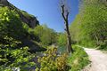
Climbing in the Natural Limestone Arch
Climbing in the natural limestone arch, set in the gorge on the Derbyshire side of the River Dove. The arch which, was formed by water erosion, is located near to Raynard's Cave, midway between Thorpe and Milldale in Derbyshire, England.
Image Ref. 30320-RDA
|
|
Buy ⁄ View
|
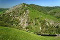
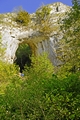
Looking Down Winnats Pass
Looking down into Winnats Pass, near Castleton in Derbyshire, England. This view from the upper end, shows the road as it climbs the 1300ft through the steep-sided ravine. Apart from the road surface, little has changed over the last 200 years.
Image Ref. 29775-RDA
|
|
Buy ⁄ View
|
Cressbrok Dale Meets Tansley Dale
In the foreground of this photo is Cressbrook Dale. It is shown at the point where it meets with Tansley Dale. A walk through Tansley Dale, shown ahead to the left, then across fields, leads one to the village of Litton in Derbyshire, England.
Image Ref. 29362-RDA
|
|
Buy ⁄ View
|
Hope Valley from Winnats Head
A view of the Hope Valley from the road at Winnats Head in Derbyshire, England. The distant hills from left to right are, Hollins Cross, Back Tor and Lose Hill, the crest of these hills, forms part of The Great Ridge.
Image Ref. 29624-RDA
|
|

Buy ⁄ View
|
Tent Sited Near Summit of Mam Tor
A tent sited near the summit of Mam Tor in Derbyshire, England. The tent was pitched on the silted ditch of what was once part of the defences of the Bronze Age hill fort. This view to the south east, shows the village of Castleton and Winnats Pass.
Image Ref. 29752-RDA
|
|
Buy ⁄ View
|
Cressbrook Dale from Mires Lane
From a high point, close to Mires Lane, this view is looking due south, and down into Cressbrook Dale, near to the village of Litton in Derbyshire, England.
Image Ref. 28865-RDA
|
|
Buy ⁄ View
|
Upperdale from Monsal Head
Looking down into Monsal Dale and then on to Upperdale. This scene is shot from a viewpoint at Monsal Head in Derbyshire, England. Along the valley is the River Wye, a foot-bridge and some isolated buildings; all are dwarfed by the surrounding hills.
Image Ref. 29455-RDA
|
|
Buy ⁄ View
|
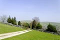
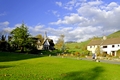
Across the Bridge at Upperdale
A view across the road bridge to the cottages, in the hamlet of Upperdale in Derbyshire, England. The bridge carries the occasional light traffic across the River Wye from the narrow track which passes under the Monsal Trail bridge.
Image Ref. 29449-RDA
|
|
 RodsImages.com