|
Buy ⁄ View
|
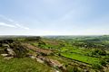
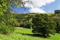
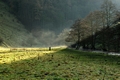
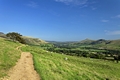
Baslow Edge and The Derwent Valley
A stunning view of the distant Baslow Edge on the left and the Derwent Valley, viewed from the top of Curbar Edge, in the Derbyshire Peak District of England.
Image Ref. 41218-RDA
|
|
Buy ⁄ View
|
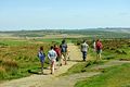
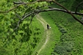
Walkers on Curbar Edge Footpath
A group of people are pictured walking along the footpath at Curbar Edge, near Curbar in the Derbyshire Peak District of England.
Image Ref. 41285-RDA
|
|
Buy ⁄ View
|
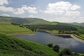
Kinder Reservoir from White Brow
A view overlooking Kinder Reservoir in the Derbyshire Peak District of England. The scene was captured from the hillside of White Brow, after following a footpath from Hayfield. The reservoir is fed from the River Kinder.
Image Ref. 36967-RDA
|
|
Buy ⁄ View
|
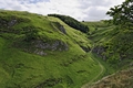
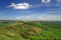
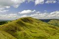
The Great Ridge, to Lose Hill
Image Ref. 34058-RDA
|
|
Buy ⁄ View
|
The Path to Back Tor
The path to Back Tor. The footpath is part of the ancient route along the Great Ridge, between Mam Tor and Lose Hill in the Derbyshire Peak District of England. The summit of Back Tor, affords spectacular views across the Vale of Edale, to the left, and across the Hope Valley, to the right of this scene.
Image Ref. 36449-RDA
|
|
Buy ⁄ View
|
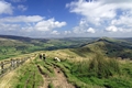
Rushup Edge, viewed from Mam Tor
Rushup Edge in the Derbyshire Peak District of England, near to the village of Edale. This scene, which was viewed from Mam Tor, shows the gently rising ridge and also the distant hill range which sweeps round to the north, to include Kinder Scout.
Image Ref. 34034-RDA
|
|
Buy ⁄ View
|
Hayfield, Derbyshire from Snake Path
Looking down on the village of Hayfield in the Derbyshire Peak District of England. The scene shows some of the houses, cottages and church, it also overlooks a couple of meadows filled with buttercups. The view was captured from Snake Path, which is an ancient footpath running between Hayfield and Kinder Scout.
Image Ref. 36935-RDA
|
|
Buy ⁄ View
|
Climbers At Curbar Edge
Climbers at Curbar Edge in the Derbyshire Peak District of England. The two climbers are pictured towards the northern end of Curbar Edge. They had just completed one climb and were walking to their next location.
Image Ref. 41279-RDA
|
|
Buy ⁄ View
|
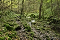
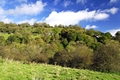
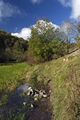
Woodland in Northern End of Monk's Dale
A wonderfully chaotic view of the woodland at the northern end of Monk's Dale, in the Derbyshire Peak District of England. After walking the length of the dale, starting near the village of Miller's Dale, I came upon this area of woodland. There were trees, fallen branches and rocks everywhere, most were covered in wet moss and with the water from the stream, it was a very slippery and difficult walk, but nevertheless, a beautiful scene.
Image Ref. 34993-RDA
|
|
Buy ⁄ View
|
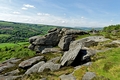
Froggatt Edge Looking North
A view from the southern end of Froggatt Edge, in the Derbyshire Peak District of England. The scene looking north along the edge, shows slabs of gritstone rock, and a glimpse of the Derwent Valley.
Image Ref. 41271-RDA
|
|
Buy ⁄ View
|
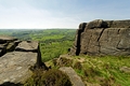
The Derwent Valley From Curbar Edge
A view of the Derwent Valley from Curbar Edge, near Curbar in Derbyshire, England. From a viewpoint between two groups of gritstone rock, high on Curbar Edge, the scene looks out onto the Derwent Valley. The treetops in the centre of the picture, are part of Bee Wood.
Image Ref. 41245-RDA
|
|
Buy ⁄ View
|
Girls Taking a Break at Hollins Cross
A group of girls pictured sitting on the hilltop at Hollins Cross on the Great Ridge, in the Derbyshire Peak District of England. The girls were taking a break after reaching the mid point along the ridge, before continuing their walk to Back Tor.
Image Ref. 34092-RDA
|
|
Buy ⁄ View
|
A Young Couple Walking In Cave Dale
A young couple pictured walking along the footpath in Cave Dale, near Castleton in Derbyshire, England. The scene is framed by tree branches, and was captured from a viewpoint high above at Peveril Castle.
Image Ref. 39497-RDA
|
|
Buy ⁄ View
|
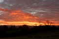
Thorpe Sunset
A sunset over the Thorpe countryside in Derbyshire, England. This view was captured from Thorpe Pasture, it shows the edge of the village and the distant hills, as darkness fell and the sky lit up, as if it was on fire!
Image Ref. 39854-RDA
|
|
Buy ⁄ View
|
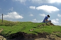
Cave Dale from Peveril Castle
Looking down on Cave Dale from Peveril Castle, at Castleton, Derbyshire, England. Cave Dale is a dry limestone valley which has very steep sides at its northern end, which is shown here. Two people pictured at the bottom centre, give an indication to the scale of the scene.
Image Ref. 39495-RDA
|
|
Buy ⁄ View
|
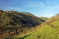
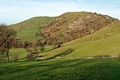
Hill Range North of Edale
A landscape scene of the range of hills just to the north of Edale, in Derbyshire, England. The view was captured from the Pennine Way. It shows a gentle slope with sheep grazing on it and then in the distance are the steeper hills displaying their beautiful autumn colours.
Image Ref. 34389-RDA
|
|
Buy ⁄ View
|
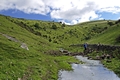
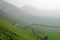
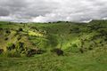
Manifold Valley and Dovecote, Swainsley
The Manifold Valley at Swainsley, near to Warslow, in the Staffordshire Moorlands, England. This scene was captured from a viewpoint on the Manifold Way and shows a view across the valley to the dovecote, which is set against a backdrop of the tree covered hillside.
Image Ref. 34518-RDA
|
|
Buy ⁄ View
|
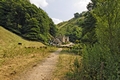
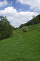
Southern End of Wolfscote Dale
A view looking towards the southern end of Wolfscote Dale, in the Derbyshire Peak District of England. This picturesque scene is close to the village of Milldale, the hill to the left is called Fishpond Bank and the distant hill is Shining Tor.
Image Ref. 37345-RDA
|
|
Buy ⁄ View
|
Across The Valley To Dovedale Wood
A high-level view across the Dove Valley to Dovedale Wood. The scene was captured from the hillside on the Derbyshire side of the valley, close to Tissington Spires. The woodland on the opposite side, covers a large area of the Staffordshire hillside and higher, on the hilltop is Air Cottage
Image Ref. 39815-RDA
|
|
Buy ⁄ View
|
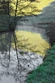
Reflections of Fishpond Bank
Near to the southern end of Wolfscote Dale in the Derbyshire Peak District of England. This high contrast scene was created by the low sunshire, catching just part of the hillside, called Fishpond Bank, and melting off some of the frost. The reflected sunshine from the bank, in turn, provided a background for the reflected trees in the river.
Image Ref. 39894-RDA
|
|
Buy ⁄ View
|
Sunbeams and Mist, Wolfscote Dale
Wolfscote Dale in the Derbyshire Peak District of England. The dale is surrounded by steep hills, which means that the sunshine does not reach some parts of the valley during the short winter months. But pictured here, was a rare burst of sunbeams as they cut through the mist, to light up part of the valley floor. A solitary stone gate post marks the centre of this scene and behind it, just visible in the mist, is a wooden footbridge spanning the River Dove.
Image Ref. 39909-RDA
|
|
Buy ⁄ View
|
Across Thorpe Cloud to Bunster Hill
Looking across the lower slopes of Thopre Cloud to Bunster Hill, at Thorpe in Derbyshire and Staffordshire, England. This view focuses on the lower area of the landscape, which is close to the southern end of Dovedale. The walkers on the right of the photo are taking the well worn path on Thorpe Cloud, which descends to the footbridge, spanning the River Dove.
Image Ref. 39782-RDA
|
|
Buy ⁄ View
|
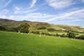
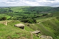
Pasture Land at Thorpe, Derbyshire
Pasture land at Thorpe in Derbyshire, England. The field pictured, which is now used as an enclosed pasture, shows the lines of ridge and furrow running across it. This usually indicates an ancient field where ploughing once took place over a long period of time. The hills behind the dry stone wall and barn, are Thorpe Cloud and Hamston Hill.
Image Ref. 39778-RDA
|
|
Buy ⁄ View
|
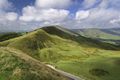
The Great Ridge and the Hope Valley
The Great Ridge and the Hope Valley in the Peak District National Park, Derbyshire, England. This view from Mam Tor, shows the Hollins Cross, Back Tor and Lose Hill, along the ridge, and below are the fields of the Hope Valley.
Image Ref. 36435-RDA
|
|
Buy ⁄ View
|
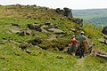
Crossing the Stream in Cressbrook Dale
A walker is pictured crossing the small stream in Cressbrook Dale, near to Wardlow in Derbyshire, England. The lady is taking advantage of the rocks which have been placed there, to allow a dry crossing. At this point, there is a gate in the dry stone wall, which gives access to Tansley Dale.
Image Ref. 34798-RDA
|
|
Buy ⁄ View
|
South from the Summit of Back Tor
An aerial view from the summit of Back Tor, in the Peak District National Park, near to Castleton in Derbyshire, England. From a viewpoint near to the overhanging rocks, this view looks south across the Hope Valley. The village of Castleton can be seen to the distant left, and the distant centre, shows a glimpse of the limestone gorge of Winnats Passs. Approaching the summit, are walkers climbing the rugged section of the Great Ridge footpath, from Hollins Cross.
Image Ref. 36508-RDA
|
|
Buy ⁄ View
|
Across The Southern End of Monk's Dale
From one hilltop to another, a view across the southern end of Monk's Dale, close to the village of Miller's Dale in the Derbyshire Peak District of England. The line of the dry stone wall and buildings, marks the route of the Limestone Way, along the far hillside.
Image Ref. 34949-RDA
|
|
Buy ⁄ View
|
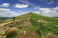
Approaching Lose Hill
Approaching Lose Hill in the Derbyshire Peak District National Park of England, near to Castleton. This is the scene that greets the many walkers who take this footpath from Mam Tor. The final hill on this long stretch is Lose Hill, which is also called Ward's Piece. A walker is shown taking the well worn diversion, to miss the wet patch on this historic footpath.
Image Ref. 36472-RDA
|
|
Buy ⁄ View
|
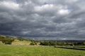
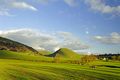
Storm Clouds, East of Monsal Head
A scene of storm clouds sweeping across the landscape near to Little Longstone, east of Monsal Head in the Derbyshire Peak District of England.
Image Ref. 34893-RDA
|
|
Buy ⁄ View
|
Along the Lower Reaches of Bunster Hill
A view along the lower reaches of Bunster Hill, near Ilam in Staffordshire, England. The distant flat-topped hill is Thorpe Cloud and over to the right, surrounded by mist, is the village of Ilam.
Image Ref. 30659-RDA
|
|
Buy ⁄ View
|
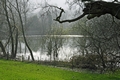
Pond near Home Farm, Ilam
A back light scene, through the trees, showing the pond near to Holme Farm at Ilam in Staffordshire, England.
Image Ref. 30740-RDA
|
|
Buy ⁄ View
|
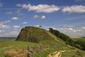
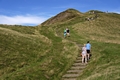
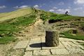
Walking Up Mam Tor
Mam Tor in the Derbyshire Peak District of England. Shown here are groups of people walking up to the summit of Mam Tor. The paved steps make it an easy climb for all ages, but the steps also help to reduce the erosion of this ancient hill fort site, which would otherwise occur from the thousands of visitors who climb this hill, each year.
Image Ref. 34202-RDA
|
|
Buy ⁄ View
|
The Vale of Edale from the Pennine Way
This view is from the Pennine Way, looking along the Vale of Edale, towards the village of Edale, in the Derbyshire Peak District of England. The Vale of Edale is a large valley running between the several hills. Broadlee-Bank Tor, is shown to the left and on the right, is Lose Hill and Back Tor.
Image Ref. 34377-RDA
|
|
Buy ⁄ View
|
North West, Along Cressbrook Dale
Looking north west along Cressbrook Dale, near to Wardlow in Derbyshire, England. This view, in the direction of Litton, was shot on a cloudy day, with a Just glimpse of sunshine breaking through. Along the dale, just hidden from sight on the left, is the entrance to Tansley Dale and Wardlow is beyond the ridge on the right.
Image Ref. 34826-RDA
|
|
Buy ⁄ View
|
Pasture Land at Ashford-in-the-Water
Pasture land at Ashford-in-the-Water, in the Derbyshire Peak District of England. This delightful pasture, beside the River Wye, shows a very popular public footpath, which is used by people walking between Ashford and Bakewell.
Image Ref. 31393-RDA
|
|
Buy ⁄ View
|
Hollins Cross on the Great Ridge
Hollins Cross on the Great Ridge between Edale and Castleton, in Derbyshire, England. Hollins Cross is also approximately half-way along the ridge, between Mam Tor and Bak Tor. In the foreground of this photo is a memorial cairn to Tom Hyett, erected by members of the Long Eaton and District Ramblers Association, in 1964.
Image Ref. 34091-RDA
|
|
Buy ⁄ View
|
Monk's Dale
Monk's Dale in the Derbyshire Peak District of England, near to the village of Millers Dale. After walking through the wooded area at the southern end of the dale, I emerged into the sunshine once more, and I came upon this delightful scene.
Image Ref. 34976-RDA
|
|
Buy ⁄ View
|
The Walk Between Ilam and Dovedale
A view looking east across the fields, showing people on the walk between Ilam and Dovedale in the Peak District of England. The walk is along a public footpath, which can be a very busy route at times, especially in the summer months. The foreground and Bunster Hill to the left, are in Staffordshire. The central hill is Thorpe Cloud and the darker area on the horizon, is close to the village of Thorpe, these areas of the landscape are both in Derbyshire.
Image Ref. 26944-RDA
|
|
Buy ⁄ View
|
Rushup Edge from Mam Tor
A view of the ridge called Rushup Edge, in the Derbyshire Peak District of England. Looking towards Lord's Seat, which is the highest point at 545 m, this scene shows the northern face of the ridge as it descends into the Vale of Edale.
Image Ref. 29654-RDA
|
|
Buy ⁄ View
|
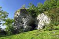
Wetton Mill Caves
Caves at Wetton Mill, in the Manifold Valley, Staffordshire Moorlands, England. These two caves are in a limestone outcrop, on a hill above the mill buildings. Part of the larger cave is open to the sky, once inside, and there are tiny holes and inter-connecting passages between the two.
Image Ref. 34737-RDA
|
|
 RodsImages.com