|
Buy ⁄ View
|
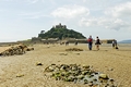
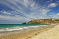
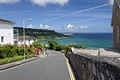
Walking To St Michael's Mount
People walking towards St Michael's Mount, in Cornwall, England. This scene at low tide shows people walking the stretch of sand between Marazion and St Michael's Mount. On the morning of this photo, a section of the Causeway was being repaired to replace some of the displaced cobbles, so people were taking a direct route across the sand. At high tide, this area is covered by the sea and access to and from the Mount is by boat.
Image Ref. 47283-RDA
|
|

Buy ⁄ View
|
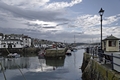
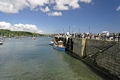
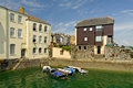
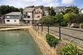
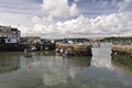
Harbourside Buildings, Porthleven
A harbourside scene at Porthleven in Cornwall, England. This view looking west across the harbour shows the buildings of Mount Pleasant Road, which include The Ship Inn and the Smithy, then above these are the houses of Claremont Terrace.
Image Ref. 47829-RDA
|
|
Buy ⁄ View
|
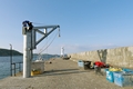
Pier, Lookout Hut and Cliffs, Portreath
Looking along the channel into the outer harbour at Portreath in Cornwall, England. To the left is the pier; with the pilchard lookout hut at the far end and to the right is the rugged face of the North Cliffs.
Image Ref. 47051-RDA
|
|
Buy ⁄ View
|
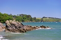
The Rugged Castle Beach, Falmouth
A view of the south facing Castle Beach at Falmouth in Cornwall, England. Falmouth has four beaches, the attractive but rugged Castle Beach looks out towards Pendennis Point and shows a tiny glimpse above the tree-line, of Pendennis Castle. The ocean here, is very popular with divers.
Image Ref. 46757-RDA
|
|
Buy ⁄ View
|
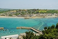
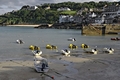
Newquay Harbour at Low Water
A coastal scene of the Harbour at Newquay in Cornwall, England. The harbour is pictured at low water; there are many fishing boats and pleasure craft of various sizes and children playing on Harbour Beach. Towards the centre of the picture is Island Pier, behind it is North Pier and to the right is South Pier, then beyond the harbour is a view of Newquay Bay. The three piers are each, Grade II listed buildings.
Image Ref. 38028-RDA
|
|
Buy ⁄ View
|
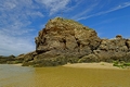
Chapel Rock, Perranporth Beach
Chapel Rock on the beach at Perranporth in Cornwall, England. Chapel Rock is a prominent feature on the lovely three mile stretch of golden sand, at this very popular seaside resort. The rock, which was pictured as the tide was going out, had a rather weather worn St Piran's flag flying at its summit.
Image Ref. 48575-RDA
|
|
Buy ⁄ View
|
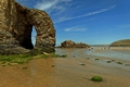
Arch Rock, Perranporth Beach
One of several prominent features on Perranporth beach is the Arch Rock formation. The scene was captured at low tide on a sunny day at this very popular seaside resort of Perranporth in Cornwall, England. Chapel Rock is also pictured in the more distant centre of the photo.
Image Ref. 48559-RDA
|
|
Buy ⁄ View
|
Charlestown Beach and Cliffs
Charlestown beach and cliffs, Cornwall, England. This view was captured from the Outer Harbour entrance. The beach is located just to the east of the harbour. Included in the photo are cottages and buildings, the sea wall, a single reinforced concrete groyne and the cliffs leading to Appletree Point.
Image Ref. 46550-RDA
|
|
Buy ⁄ View
|
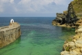
Inner Harbour Entrance, Charlestown
The entrance to the inner harbour and dock, at Charlestown in Cornwall, England. The port, which was designed for small sailing vessels, was built in the 18th century to facilitate the export of copper ore from local mines and China clay from St Austell.
This scene shows the narrow harbour entrance, the dock gates, the cliffs and above the dock is a row of white painted cottages.
Image Ref. 46546-RDA
|
|
Buy ⁄ View
|
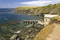
The North Cliffs of Portreath
The North cliffs of Portreath in Cornwall, England; photographed from the sandy beach. The features of this scene are Horse Rock, jutting out into the Atlantic Ocean, just to the left of the cliffs, the Daymark on the cliff top, the pier and a pilchard lookout hut at the seaward end of the pier. At the other end, just above the pier is the Lower Pilots Lookout Hut. Then dotted around the cliff, are a few cottages and other buildings.
Image Ref. 47093-RDB
|
|
Buy ⁄ View
|
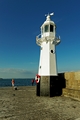
Mevagissey Outer Harbour
A brightly lit scene in the outer harbour of Mevagissey, in Cornwall, England. The evening sunshine is reflecting off the small boats and harbour walls and is contrasting with the heavily overcast sky. The Harbour Lighthouse is shown on the south breakwater at the harbour entrance.
Image Ref. 46652-RDA
|
|
Buy ⁄ View
|
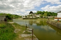
The Harbour With No Boats, Pentewan
A tranquil harbour scene at Pentewan in Cornwall, England. The scene is very unusual because the harbour now has no boats, it has been cut off from the sea since the 1960s, when the harbour entrance finally silted up.
There has been a harbour at Pentewan since medieval times, when the villagers were mainly involved in pilchard fishing. Following plans to turn Pentewan into a major china clay port and also to improve the existing fishery, much of the harbour was rebuilt between 1818 and 1826, by Sir Christopher Hawkins, a local land and quarry owner. At first the port thrived, exporting up to a third of Cornwall's china clay, but the continual problems with silting and the rise of rival ports at Charlestown and Par, led to the demise of Pentewan as a port, a little over a century later. The last trading ship left Pentewan port in1940. Wikipedia was the main source, for this information.
Image Ref. 46603-RDA
|
|
Buy ⁄ View
|
The Causeway To St Michael's Mount
The Causeway to St Michael's Mount, in Cornwall, England. This view from the Marazion end, shows people walking towards the mainland and in the distance, at the other end where the Causeway sweeps round to the right, a few groups of people are pictured approaching the island. The incoming tide was quickly covering the causeway and the distant people were almost knee deep in water at the time this photo was taken. The castle and island harbour are also shown.
Image Ref. 42007-RDA
|
|
Buy ⁄ View
|
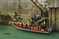
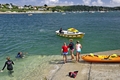
Boarding The Dive Boat, Newquay Harbour
A group of scuba divers are shown, boarding a dive boat in the harbour at Newquay in Cornwall, England. The inflatable boat was alongside the North Pier and the divers are pictured as they were descending a flight of stone steps, to the boat. One of the harbour seals came to investigate.
Image Ref. 38048-RDA
|
|
Buy ⁄ View
|
Evening at Custom House Quay, Falmouth
An evening landscape view of Custom House Quay, showing part of the town and harbour at Falmouth in Cornwall, England. The coastal scene, which includes the quayside buildings and the boats at their moorings in both the quay and in the harbour, was captured in the fading daylight, as the clouds closed in.
Image Ref. 38765-RDA
|
|
Buy ⁄ View
|
Harbour Lighthouse, Mevagissey
The harbour lighthouse at Mevagissey in Cornwall, England. The hexagonal cast-iron lighthouse is situated at the seaward end of the south breakwater. The lighthouse was built in 1896 and stands 29 feet tall, its light can be seen across St Austell Bay, which is a distance of 12 miles. The lighthouse also has a foghorn.
Image Ref. 41546-RDA
|
|
Buy ⁄ View
|
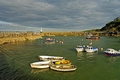
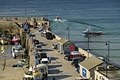
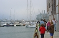
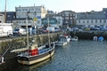
Penzance Harbour Scene
A harbour scene at Penzance in Cornwall, England. Pictured here are, small boats at their moorings near the harbour wall, cars and vans on Wharf Road, the old lifeboat house and various other buildings of the town.
Image Ref. 37853-RDB
|
|
Buy ⁄ View
|
St Mawes Ferries Alongside the Pier
St Mawes Ferries berthed alongside the Prince of Wales Pier at Falmouth in Cornwall, England. The nearer ferry was boarding for the 20 minutes journey, when this photograph was taken. The boats appear to be a long way down from the top of the pier, this was due to a an unusually low tide, on that day. Many yachts are pictured at their moorings in the harbour.
Image Ref. 37469-RDA
|
|
Buy ⁄ View
|
Along The South Pier, Newquay Harbour
A view looking along the South Pier of Newquay Harbour, at Newquay, Cornwall, England. The scene captured at low water, shows boats at their moorings, various vehicles parked on the pier, the Harbourmaster Office, an old lifeboat on display, lobster pots, two boats sailing in the open water of the bay, and people enjoying the sunny day.
Image Ref. 38088-RDA
|
|
Buy ⁄ View
|
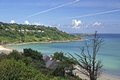
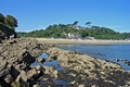
Carbis Bay to St Ives
The beautiful Carbis Bay and the distant headland of St Ives, in Cornwall, England. The lovely privately owned beach of golden sand, is sheltered by steep cliffs which have cottages dotted amongst the mass of trees.
Image Ref. 38804-RDA
|
|
Buy ⁄ View
|
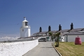
Lizard Lighthouse, Cornwall
A view of Lizard Lighthouse, keepers' cottages and one of several examples of marine buoys, at Lizard Point in Cornwall, England. Lizard Point is the most southerly part of the British mainland and the waters around the headland are treacherous. Numerous razor-sharp rocks lie just below the surface, which have been the cause of countless maritime disasters.
The current lighthouse, with its octagonal tower, was first lit in 1752. In those days the light was produced by coal fires. A foghorn was added in 1878 and the lighthouse was electrified in 1924. The site, which also has a heritage centre and a bell tower, is the largest lighthouse complex in the world. The first lighthouse on this site was built by a pirate!
Image Ref. 37548-RDA
|
|
Buy ⁄ View
|
Mulberry Quay, Falmouth
A waterfront view of Mulberry Quay, a few small boats at their moorings and the buildings of Market Strand, at Falmouth in Cornwall, England. This colourful scene was captured from the Prince of Wales Pier.
Image Ref. 41875-RDA
|
|
Buy ⁄ View
|
Along The South Breakwater, Mevagissey
The south breakwater at the fishing port of Mevagissey in Cornwall, England. This view along the breakwater, shows a crane, the fishing boat Celtic Dawn, boxes of ropes and fishing nets, the outer harbour to the left and at the far end is the harbour lighthouse.
Image Ref. 41550-RDA
|
|
Buy ⁄ View
|
Rocks off Trebah Beach, Cornwall
A view of the jagged rocks, which are just off Trebah beach, in Cornwall, England. The scene was captured from the beach, looking east into Polgwidden Cove, in the Helford River estuary. Many small boats were moored in the cove and amongst the trees at Durgan, smoke was rising from a bonfire.
Image Ref. 41658-RDA
|
|
Buy ⁄ View
|
Marazion From St Michael's Mount
Marazion from St Michael's Mount, in Cornwall, England. From a viewpoint on a lower gun deck of the castle, the scene looks down onto the harbour with its many small boats. The submerged Causeway can be seen winding its way across Mounts Bay to the far beach, and the seafront and buildings of Marazion.
At low water, depending on the tides, the Causeway is usually uncovered for a short time, which allows people to walk to and from the island. When the Causeway is covered by the sea, people are ferried to and from the island in small boats.
Image Ref. 42071-RDA
|
|
Buy ⁄ View
|
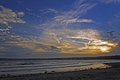
Sunset Over Penzance, Cornwall
Captured from the beach at Marazion, this scene across Mount's Bay, shows the beginning of a sunset over Penzance, in Cornwall, England.
Image Ref. 37973-RDA
|
|
Buy ⁄ View
|
Beside The Quay, Penzance
A picturesque location beside the Quay at Penzance in Cornwall, England. This lovely, tranquil garden setting, which overlooks the quay and slipway, has lush mature shrubs and palm trees to the rear and a backdrop of modern-looking cottages.
Image Ref. 37861-RDA
|
|
Buy ⁄ View
|
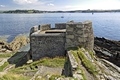
Little Dennis Blockhouse, Falmouth
The Little Dennis Blockhouse, near Pendennis Point at Falmouth in Cornwall, England. This D-shaped blockhouse, or gun tower, was constructed around 1538-1539 and together with a similar one on the opposite headland at St Mawes, formed the earliest defence of the Fal Estuary. The sea lanes in the estuary known as the Carrick Roads were of strategic importance and needed to be protected against the threat of invasion from France and Spain. The blockhouses, which had cannons mounted at several gun ports, were an interim defence measure ordered by Henry VIII, while the building of castles at Pendennis and St Mawes was being completed.
Image Ref. 39283-RDA
|
|
Buy ⁄ View
|
The Old Lizard Lifeboat Station
The old Lizard Lifeboat Station at Lizard Point, Cornwall, England. Set among the rocks of Polpeor Cove, this now disused lifeboat station, was in operation from 1914 until 1961. There have been several lifeboat stations at the Lizard since 1859. This was the third at Polpeor Cove, the previous two were built higher up the cliff. The exposed position and the treacherous rocks, made launching and recovery up the slipway, difficult and often dangerous. The next station, was built in 1961 at a more sheltered location nearby, at kilcobben Cove. This was in use until 2010, when it was demolished and replaced by the latest state-of-the-art (RNLI) station, which was constructed on the same site.
Image Ref. 37527-RDA
|
|
Buy ⁄ View
|
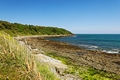
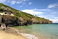
Rocky Cliff Face of Trevaunance Cove
A view of Trevaunance Cove near St Agnes in Cornwall, England. This scene from the beach, shows the rocky cliff face, on the west side, of this north facing little cove. The weather here can change rapidly, so the shelter situated above the steps, can provide some welcome protection in a storm, as I soon found out.
Image Ref. 37757-RDA
|
|
Buy ⁄ View
|
Swimmers on the Slipway, St Mawes
The slipway beside the harbour at St Mawes in Cornwall, England. Pictured, are swimmers and two of the girls about to jump back into the ocean. A canoe, small boats and distant yachts are included in this coastal scene.
Image Ref. 38732-RDA
|
|
Buy ⁄ View
|
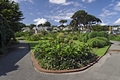
Queen Mary Gardens, Falmouth
The main flower bed of Queen Mary Gardens at Falmouth in Cornwall, England. The gardens are situated beside Spernen Wyn Road and just behind Gyllyngvase Beach.
Image Ref. 39317-RDA
|
|
Buy ⁄ View
|
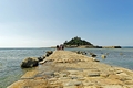
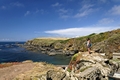
Old Lizard Head and Polpeor Cove
Looking west from Lizard Point, this view shows the rocky coastline of Polpeor Cove and part of the distant Old Lizard Head, in Cornwall, England. Below the rocks which the girl is standing on, is a glimpse of the old lifeboat station and the slipway.
Image Ref. 37532-RDA
|
|
Buy ⁄ View
|
The Approach to the Beach, Carbis Bay
The approach road to the beach at Carbis Bay in Cornwall, England. The village of Carbis Bay, overlooks a bay of the same name. The village is next to the town of St Ives, and Carbis Bay is just part of the much larger, St Ives Bay. The steep road pictured here is Porthrepta Road, which leads down to the small railway station and on to Beach Road, terminating at a beautiful sandy beach. The headland of St Ives is shown beyond the wooded area of Porthminster Point.
Image Ref. 38808-RDA
|
|
Buy ⁄ View
|
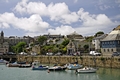
St Ives Harbour, 01
A view across the harbour towards Porthminster Beach, at St Ives, Cornwall, England. The boats and inflatable craft are shown at their moorings in the harbour at low water, where they are catching the light from the evening sun.
Image Ref. 38832-RDA
|
|
Buy ⁄ View
|
Falmouth Harbour - 02
This is a view along the harbour looking towards the docks at Falmouth, Cornwall, England. The subdued colors in the distance are due to the mist which was descending on the area.
Image Ref. 15078-RDA
|
|
Buy ⁄ View
|
St Mawes from Pendennis Point
A view of St Mawes from Pendennis Point, at Falmouth in Cornwall, England. St Mawes is a small town on the Roseland Peninsula which stands opposite to Falmouth. The waterway separating these two coastal headlands is called Carrick Roads. Both headlands have well preserved castles, which for over four hundred years, protected this south-west stretch of the Cornish coast.
Image Ref. 39299-RDA
|
|
Buy ⁄ View
|
Custom House Quay and Falmouth Harbour
Custom House Quay at Falmouth in Cornwall, England. This view at low water, shows a few small boats at the quayside moorings and beyond the entrance to the quay, a glimpse of the many yachts and boats in the harbour.
Image Ref. 37480-RDA
|
|
Buy ⁄ View
|
Maenporth, Cornwall
The small cove of Maenporth, near to Falmouth in Cornwall, England. This view is from the rock pools to the beach.
Image Ref. 15043-RDA
|
|
Buy ⁄ View
|
Custom House Quay, Falmouth
Pictured here is the Custom House Quay, at Falmouth in Cornwall, England
Image Ref. 14963-RDA
|
|
 RodsImages.com