This gallery displays landscape countryside photos taken within the Peak District of England.
The Peak District is located in central and northern England, covering much of north Derbyshire, and parts of Staffordshire, Cheshire, Greater Manchester, and also South and West Yorkshire. The Peak District is conventionally split into two main areas, which are, the Dark Peak in the north, and the White Peak in the south. Within this area is The Peak District National Park. It covers most, but not all of this vast area.
The Peak District National Park, which covers 555 square miles, was designated a national park in 1951 and was the first national park in the United Kingdom. The areas of the national park within Staffordshire, are usually referred to as the Staffordshire Moorlands or the Staffordshire Peak District. The only town directly within the national park is Bakewell, there are however many villages and hamlets, and there are other towns just outside of the national park.
The Peak District National Park is claimed to be the second most visited national park in the world. Much of the land is open to the public and is criss crossed with public footpaths, bridleways and trails. There are also the remains of many ancient packhorse routes and packhorse bridges. Visitor activities include, walking, rambling, climbing, orienteering, canoeing, cycling, mountain biking, potholing, hang gliding and paragliding.
All the fine art photos in this gallery have been taken within the wider area of the Peak District, but most are from the actual Peak District National Park. Photos are available in various sizes and finishes, including photo, canvas, acrylic, metal and poster prints and greeting cards. More details are shown below.
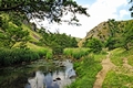
A view of Wolfscote Dale, near to Gipsy Bank Bridge, on the Staffordshire and Derbyshire border, in the Peak District, England. The scene shows the River Dove, flanked by rocky outcrops on both hillsides, grasses on the river banks and overhanging tree branches.
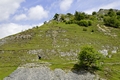
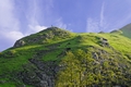
Cressbrook Dale in the Derbyshire Peak District of England. Pictured here is the eastern hillside of Cressbrook Dale at a point opposite to its junction with Tansley Dale. The scene shows the steep hillside with rocky outcrops, trees, a scree slope and a cave.
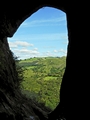
A view from Thor's Cave, looking out onto the Manifold Valley, in the Peak District National Park, near Wetton, Staffordshire Moorlands, England. This large cave in the limestone rock has been formed over thousands of years by the effects of water and wind. The hole in the rock face shown here is like a small window, the entrance to the cave is many times larger.
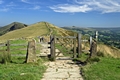
A gateway on the Great Ridge near to Castleton, in the Derbyshire Peak District of England. The wooden gateway stands on a paved section of the Great Ridge, between Mam Tor to the rear and Hollins Cross which lies ahead of the gateway in this picture. The ancient stone gate posts shown here indicate that this is also the site of a much earlier gateway. Several people are pictured walking the footpath, which is probably the most walked ridge in England. The distant hills of Back Tor and Lose Hill are shown to the left and on the right is a glimpse of the Hope Valley.
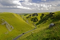
A view looking along Winnats Pass, which is near to the village of Castleton in the Derbyshire Peak District of England. The road winds its way through the steep-sided ravine and there are numerous towering limestone pinnacles on each side. From the upper end, the road descends 1300ft (396m) to the Castleton end and at its steepest point; it has a gradient of 28% (1 in 3.5).
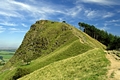
Back Tor is one of the hills on the Great Ridge, in the Derbyshire Peak District of England. It is located between the valley, villages of Edale, on one side and Castleton on the other side. Back Tor is a gritstone hill in the Dark Peak area, with a height of 1,463 feet, (446 metres). This hill is much more stable than Mam Tor, which is prone to land slips. The image shows hill walkers making their way to the summit and a few people already at the top, who were, no doubt, enjoying the spectacular views.
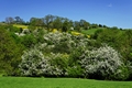
A colourful hillside, country landscape of May blossom on the trees and fields of green and golden buttercups. This lovely vibrant scene was captured near to Coldwall Bridge, south west of Thorpe in Derbyshire, England.
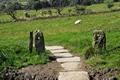
A pair of ancient stone gate posts, located on the Pennine Way at Upper Booth, near to Edale in the Derbyshire Peak District of England. The gate posts probably date from the 17th to 18th century.
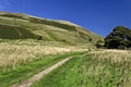
A view along a tiny section of the pennine way, looking towards Broadlee-Bank Tor, near to Edale in the Derbyshire Peak District of England. The two people in the distance are walking in the direction of Edale and they are dwarfed by the hill to the left. On the right are the remains of a derelict barn.
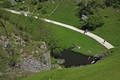
Looking down on the Dovedale footpath, from the limestone hill called Thorpe Cloud, at Dovedale in the Derbyshire Peak District of England. This aerial view shows people relaxing in the sunshine beside the River Dove, near to the Stepping Stones. Two children were wading across the river and a few people were enjoying a walk through the steep-sided dale.
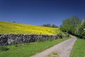
A view along one small part of the Limestone Way, near to the village of Thorpe in the Derbyshire Peak District of England. The Limestone Way is a long-distance bridleway through the White Peak in Derbyshire. The bridleway runs from just south east of Castleton, to Rocester, which is over the county boundary in Staffordshire, a distance of 46 miles (74 km).
The scene includes the bridleway, flowering trees, a typical dry stone wall and behind it is a field of golden buttercups.
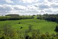
A view looking south from the village of Thorpe in Derbyshire, England. This countryside scene, which was captured from the Limestone Way, shows cattle grazing on the far hillside. The field has evidence of earthworks and is surrounded by wooded areas.
Image Ref. 30964-RDA
Purchasing Details
The photos in this gallery have individual direct links to the same photos on my personal website with Pixels.com.
Pixels.com/Fine Art America is one of the largest and most respected custom framers in the world. The prints are of museum-quality and the expertly assembled frames, which are ready to hang, are produced at wholesale prices. The quality and prices of their frames just cannot be beaten.
Pixels.com/FAA now has Multiple Fulfilment Centres in several countries and ships to world wide destinations. When you place an order, the artwork will automatically be printed and manufactured at the nearest of its Fulfilment Centres to your delivery address.
If for any reason, you are not satisfied with your purchase when it arrives, you may mail it back to Pixels.com/Fine Art America within 30 days, for a full refund of the purchase price. In the unlikely event that your purchase has a defect in quality, the outgoing and return shipping charges, will also be refunded.
Photo products are available in many options and sizes. Prices are in US Dollars.
 RodsImages.com